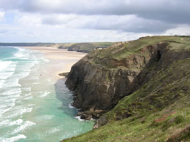
Perranporth is a seaside resort town of 3,066 people on the north coast of Cornwall, and the reason to make the trip from Newquay is the beach. Perran Beach runs two miles (3 km) north-east to Ligger Point, facing west onto Perran Bay and the open Atlantic, backed by sand dunes reaching nearly a mile inland. The town itself is small: one main street of shops, cafés and pubs at the southern end of all that sand.
Perranporth around 7 miles south-west of Newquay; the straight-line distance is 9.6 km. It lies 2.1 miles east of the St Agnes Heritage Coastline, is the largest settlement in the parish of Perranzabuloe, and holds an electoral ward of its own whose population was 4,270 in the 2011 census.
The name is the point of the place. It comes from Porth Peran, Cornish for the Cove of Saint Piran, patron saint of Cornwall, who founded St Piran’s Oratory on Penhale Sands in the 7th century. The oratory then lay buried under the dunes for centuries and was only unearthed in 1835 — the sand here moves on that scale.
The beach carries 4.8 from 5,606 Google reviews, and what reviewers describe is scale rather than prettiness. A visitor in July 2026 wrote that “At low tide, Perranporth beach can measure up to a quarter of a mile (approx. 400 metres) wide. As the water recedes, it merges with Perran Sands and Ligger Bay to create a massive expanse of golden sand stretching for 2 to 3 miles.” Low water is a different place from high, when the sand narrows against the cliffs.
There is a hazard attached. Lifeguards patrol from May to September and the beach is generally safe for bathing, but there are dangerous rip currents around Chapel Rock at ebb tides — and the ebb is exactly when the retreating water tempts people out to the rock. It is a surfing and kite-surfing beach with a long beach break, so the water is rarely still.
Parking divides opinion, which usually means it depends when you arrive. A visitor in August 2026 advised, “Parking can be tricky, so try to get there before 11 if possible (there are 2 car parks adjacent to the beach)”. A visitor in July 2026 said the opposite in three words: “Lots of parking.” Assume the earlier arrival.
Penhale Sands, the dune system behind the beach, is not scenery you skirt round: it is used for orienteering competitions and holds an 18-hole links golf course. Perranporth Golf Club, north of the town, has 4.6 from 390 Google reviews; a visitor in July 2026 called it “a inspiring links course with amazing views of Perranporth, the beach and dunes.”
The dunes carry rare plants and insects, including Cornwall’s largest colony of the silver-studded blue, a Red Data Book species. The far northern end of the beach is used as a naturist beach, and Perran Sands, a sprawling holiday camp and caravan site, sits north of the town centre. South-west of the town the coast turns rocky, cliffs rising to about 300 feet (90 metres) at Cligga Head, protected as the Cligga Head SSSI for its geology and biology.
The town is centred on St Piran’s Road, part of the B3285: shops, cafés and pubs, then the beach. The Watering Hole, 4.4 from 4,753 Google reviews, is the one people name, and its appeal is positional. A visitor in July 2026 asked, “where else can you get a pint actually on the beach watching the sunset and tide next to your bench”.
Perranporth Boating Lake, 4.6 from 423 Google reviews, is the quiet alternative when the beach is full: a small lake with gardens, ducks and geese, which a visitor in June 2026 called a “Peaceful place to sit or walk”. Perranzabuloe Museum and St Piran’s Cross both sit at 4.5, from 30 and 26 Google reviews — samples too small to weigh heavily.
Three fixtures anchor the year: The Loudest Shout, a three-day sea-song and shanty festival over the third weekend in April; Tunes in the Dunes, a music festival on the dunes with acts including Craig David and Fatboy Slim; and Perranporth SLSC’s Extreme Surf Triathlon each September, a sea swim, a hill cycle and a run through dunes and cliffs.
The cliffs at the south end of the beach hold natural arches, stacks and tin-mining adits: the industry came long before the tourism. John Woodward (1688–1728) recorded iron ore mined from a large vein on the beach, and in the 1860s ore was hauled up the cliff by a ‘puffer’ engine and taken from Gravel Hill Mine, at the north end of Perran Beach, to a quay on the Gannel. The Cligga Head Wolframite Mine and Explosives Factory, 4.6 from 105 Google reviews, is the industrial site people walk to now; Perranporth Airfield above those cliffs was an RAF fighter station in the war and is a civil airfield today.
The coast took ships too. The Voorspoed ran ashore in a northerly gale in Perran Bay on 7 March 1901 while sailing from Cardiff to Bahia, and the wreck was one of the last to be looted. Above the cliffs at Droskyn Point there is a youth hostel and, near it, 19th-century Droskyn Castle, once a hotel and now flats. Winston Graham lived here 34 years, and his Poldark novels are based on this area.
By road, St Piran’s Road is part of the B3285, the Newquay to St Agnes road, and that is the direct link between the two towns. There is a long-distance National Express coach, service 316, but it runs between London and Perranporth rather than from Newquay.
There is no train. From 1903 the town was served by the Truro and Newquay Railway, running Chacewater to Newquay with Perranporth the principal intermediate stop and a second station at Perranporth Beach Halt; the line closed in the 1960s. Beyond the B3285 and that coach, the research pack establishes no scheduled bus or rail service between the two towns, so plan on driving or a pre-booked transfer.
Two car-free options exist. The South West Coast Path runs past the town, so the trip can be walked as a coastal stage. And the nearest bicycle rental to Newquay is here rather than in Newquay itself: Custom Cycle Tours Cornwall on St Piran’s Road, 5.0 from 19 Google reviews, 9.1 km from the Newquay centre.
The village and what is around it, at walking scale.
Open any of them in Google Maps for directions and current opening.
Attractions, prices and availability in Newquay
These come from GetYourGuide's booking widget, which sets their cookies in your browser. Consent to load it and see the attractions and prices.
Background on Perranporth draws on its Wikipedia article, text there being available under CC BY-SA 4.0.